120 Minute Read
Last Updated: Nov 12th, 2025
Technical Report Author
Chris O Yoder
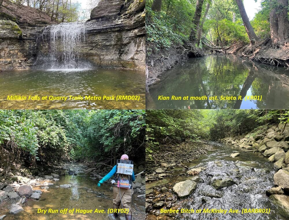
This survey is the first accomplished under a comprehensive, regional monitoring plan that was developed in 2023-24 with support from Columbus DWR. The Central Ohio Watersheds Biological and Water Quality Assessment Plan was developed to implement a watershed based approach to assessing the quality and status of rivers and streams within DWR sewersheds, Blueprint Columbus program[1] areas, and the MS4 stormwater areas of Central Ohio beyond the previous surveys of the Scioto River and Olentangy River mainstems in 2020 and 2022. Twenty-five (25) sites within five (5) tributaries that enter the Scioto River between the Griggs Reservoir (RM 137.52) and the Jackson Pike Water Reclamation Plant (WRP; RM 126.5) were sampled. All have small watershed areas between 1.4 and 9.4 square miles. The survey included four (4) sites in the Roberts Millikin Ditch subwatershed, nine (9) in the Barbee Ditch subwatershed, nine (9) in the Dry Run subwatershed, two (2) in Kian Run, and a single site in Evans Run. Dry Run is directly related to Blueprint Columbus program with all other subwatersheds including interests related to MS4 stormwater permitting, the DWR sewer system, and local issues. Sampling was conducted for water chemistry, sediment chemistry, habitat, and biological assemblages. Escherichia coli (E. coli) bacteria counts were determined to assess the status of the Primary Contact Recreational (PCR) use, but also as an indicator of organic pollution. Parameters consistent with an Ohio EPA nutrient effects assessment methodology were also collected including two forms of chlorophyll a and continuous dissolved oxygen (D.O.), temperature, pH, and conductivity at six (6) locations in the downstream portions of Roberts Millikin Ditch (1 site), Barbee Ditch (2 sites), Dry Run (2 sites), and Kian Run (1 site). Habitat quality was assessed with the Qualitative Habitat Evaluation Index (QHEI) and the biological assemblages included fish and macroinvertebrates consistent with Ohio EPA methods and the biological criteria for assessing the status of aquatic life use designations per the Ohio WQS (OAC 3745-1-07) at all sites. The 2024 bioassessment was conducted under a Level 3 Project Study Plan (PSP) submitted to and approved by the Ohio Credible Data Program. As such the results of the biological and habitat assessment can be used for purposes specified by the Ohio Credible Data Law and Regulations.
The accounting of potential pollution sources included the novel use of the CWP GIS database about “sewer features” within the 2024 study area. Data about the collection system that conveys wastewater to one of the two major wastewater reclamation facilities (Jackson Pike or Southerly) was furnished by CWP in the form of shapefiles that contained dimensional and locational information about 41 different features of the system, 21 of which were deemed a potential source of sewage or other pollutant releases to surface waters. The sanitary sewer system in the 2024 study area includes 1,082 miles of separate sanitary sewers that transport wastewater to the Jackson Pike Water Reclamation Plant (WRP) that serves the western half of Franklin County and the central portion of Columbus. The stormwater collection system consists of an additional 36.1 miles of piping. A Franklin Co. Soil and Water Conservation District (FCSWCD) inventory of conveyances to area streams that described their type (e.g., pipe type, swale) and “illicit discharges” that showed visual or odorous evidence of carrying pollutants was included.
The principal goal of the 2024 biological and water quality assessment was to assess the status of the fish and macroinvertebrate assemblages that are the principal determinant of aquatic life use attainment status in Ohio. Historical surveys by Ohio EPA have been comparatively sparse, with what sampling that has been accomplished dating to 1995 with other surveys in 2003 and 2023. The 2024 survey represents the first fully comprehensive baseline assessment done on a watershed basis. Each subwatershed is dominated by urban/suburban, commercial, and industrial land uses with an accompanying mosaic of water quality, hydrological, and habitat alterations, some of which pose difficult restoration and protection challenges. Out of the 15 individual streams assessed in 2024, only three (3) are currently designated in the Ohio WQS while the remaining 12 are unlisted and hence undesignated. Trabue Run is listed as being designated, but being tributary to the as yet undesignated Barbee Ditch mainstem, it is out of sequence in the WQS. Seven (7) or nearly one-half of the 15 stream reaches are recommended for Primary Headwater Habitat Class 2 with all except two (2) sites in the Dry Run subwatershed and the single site in Evans Run having drainage areas <1.0 square miles, the smallest being 0.22 square miles in an unnamed tributary to Trabue Run at RM 2.70. The remaining stream reaches are recommended as Warmwater Habitat (WWH) with Kian Run retaining the current designation of MWH-C. All sites were evaluated against the PCR recreation use following current Ohio EPA policy. A single site in Trabue Run was in full attainment of WWH, two (2) sites, one in Dry Run and one in the unnamed tributary to Dry Run, were in partial attainment. Of the remaining sites that were evaluated as WWH, all were in non-attainment with six (6) as NON-Fair, four (4) as NON-Poor, and two (2) as NON-Very Poor. Five (5) sites were limited by poor or very poor macroinvertebrate narratives accompanied by fair IBI scores and one (1) site was limited by a poor IBI score. The remaining sites had equivalent fish and macroinvertebrate narratives.
Levels of urban pollutants in this study reflected the mosaic of stressors that result in the uniform impairment of the aquatic life uses. This includes diverse sources that range from organic enrichment signatures and exceedances of upper reference and other chemical effect thresholds for aquatic life. The most pervasive indicator of organic enrichment was E. coli in combination with biological organic enrichment signatures. While these occurred throughout the 2024 study area, they tended to be the most concentrated in the Dry Run subwatershed, a tributary of which includes a Blueprint Columbus project and other sources including the concentration of sewage features, FCSWCD located conveyances, and a scattering of home sewage treatment systems (HSTS). Chlorides were uniformly elevated, but moreso in certain subwatersheds and in proximity to concentrations of commercial developments. Sporadic elevated concentrations of pollutants such as ammonia-N in the lower mainstem of Dry Run are an indication of episodic releases of sewage. Industrial pollutants were the most numerous in Kian Run. An elevated copper value in Evans Run may be an indication of periodic biocide applications. Nutrients were not an issue of concern based on the Ohio Stream Nutrient Assessment Procedure (SNAP) assessments at six (6) representative sites in five (5) of the six (6) subwatersheds that were assessed.
The assessment of recreational use attainment using mean and maximum E. coli results revealed consistent exceedances of the mean and Statistical Threshold Value criteria for Primary Contact Recreation (PCR) at every site sampled in 2024. Twelve (12) mean values exceeded the STV while eight (8) exceeded the SCR criterion a result that amplifies the magnitude of the E. coli PCR exceedances. All except three (3) of the maximum values exceeded the SCR criterion with the highest value of 9,600 cfu/100 mL at the lowermost site in Dry Run. Generally the mean and STV exceedances were the highest and most consistent in the Dry Run subwatershed with the maximum at all sites exceeding the Secondary Contact Recreation (SCR) criterion and the mean at five (5) sites. The remaining mean values and two of the minimum values exceeded the STV with 4 minimums exceeding the mean criterion. The minimum at a site in upper Dry Run had a very low minimum value of 41 cfu/100 mL. The Barbee Ditch subwatershed also had numerous maximum value exceedances of the SCR criterion, but at a lesser magnitude of exceedance compared to Dry Run. The four sites in Roberts Millikin Ditch also had maximum exceedances of the SCR criterion at three (3) sites with the highest values in the unnamed tributary at RM 0.40. Evans Run had similar exceedances of the minimum, mean, and maximum values to Barbee Ditch. Kian Run had a maximum E. coli of 3,600 cfu/100 mL at the upstream site. Taken together the results indicate sustained exceedances of the PCR recreational use E. coli criteria during summer-fall normal flows, an indicator of organic enrichment persisting during low flow conditions instream. While these are what are considered dry weather data, the residual effects of wet weather related inputs are also a factor. However, rainfall was well below normal in 2024 hence dry weather inputs are likely occurring on a regular basis.